There is no other place I’d rather be than teaching and learning with my girls. The freedom that comes with homeschooling allows me to pursue opportunities to travel and learn as much as we can while experiencing things first hand! Welcome to our blog about planning our next big adventure, the Lewis and Clark Trail! The three of us girls plan on a 40+ day adventure of learning all we can about the biology, botany, geography, geology, economics, and civics (and more) associated with the Corps of Discovery journey of 1804-1806. Join us on our journey!

Wednesday, August 14, 2013

August 14, 1804

Journal by Clark

14th August Tuesday 1804

a fine morning wind from the S E    The men Sent to the Mahar Town last evening has not returned    we Conclude to Send a Spye to Know the cause of Their delay    at about 12 oClock the Party returned and informed. us that they Could not find the Indians nor any fresh Sign, those people have not returned from their Buffalow hunt, Those people haveing no houses no Corn or any thing more than the graves of their ancesters to attach them to the old Village, Continue in pursuite of the Buffalow longer than others who had greater attachments to their native Village— the ravages of the Small Pox [NB: about 4 years ago] (which Swept off 400 men & women & Children in perpoposion) has reduced this Nation not exceeding 300 men and left them to the insults of their weaker neighbours which before was glad to be on friendly turms with them—    I am told whin this fatal malady was among them they Carried ther franzey to verry extroadinary length, not only of burning their Village, but they put their wives & Children toD[e]ath with a view of their all going together to Some better Countrey—    They burry their Dead on the tops of high hills and rais mounds on the top of them,—    The cause or way those people took the Small Pox is uncertain, the most Probable from Some other Nation by means of a warparty

Journal Reference:
Lewis, M., Clark, W., and Members of the Corps of Discovery. (2002). September 4, 1806. In G. Moulton (Ed.), The Journals of the Lewis and Clark Expedition. Lincoln: University of Nebraska Press. Retrieved Oct. 1, 2005, from the University of Nebraska Press / University of Nebraska-Lincoln Libraries-Electronic Text Center, The Journals of the Lewis and Clark Expedition web site:

Saturday, August 3, 2013

August 3, 1804 Council Bluffs


Journal entry by Clark

August 3rd, Friday 1804

mad[e] up a Small preasant for those people in perpotion to their Consiqunce.    also a package with a meadile to accompany a Speech for the Grand Chief 〈which we intend to send to him〉    after Brackfast we Collected those Indians under an orning of our Main Sail, in presence of our Party paraded & Delivered a long Speech to them expressive of our journey the wirkes of our Government, Some advice to them and Directions how They were to Conduct themselves, 〈made one〉 the princapal Chief for the nation 〈to whom〉 being absente we sent him the Speech flag Meadel & Some Cloathes.    after hering what they had to say Delivered 〈two of〉 a medal of Second Grade to one for the Ottos & and one for the Missourie 〈part of the nation〉 present and 4 medals of a third Grade to the inferior Chief    two for each tribe. Those two parts of nations, Ottos & Missouries now 〈forming one of〉 residing together is about 250 men are 〈nearly equal in number〉 the Ottoes Composeing ⅔d and Missourie ⅓ part

Those 〈people〉 Chiefs all Delivered a Speech acknowledgeing Their approbation to the Speech and promissing to prosue the advice & Derictions given them    that they wer happy to find that they had fathers which might be depended on &c.

We gave them a Cannister of Powder and a Bottle of whiskey and delivered a few presents to the whole after giveing a Br: Cth: [breech cloth] Some Pain guartering & a Meadele to those we made Cheifs    after Capt Lewis's Shooting the air gun a feiw Shots (which astonished those nativs) we Set out and proceeded on five miles on a Direct line passed a point on the S. S. & round a large Sand bar on the L. S. & Camped on the upper point. The Misquitors excessively troublesom this evening    Great appearance of wind and rain to the N. W.    we prepare to rec've it—    The man Liberty whome we Sent for the Ottoes has not Come up    he left the Ottoes Town one Day before the Indians. This man has eithered tired his horse or, lost himself in the Plains    Some Indians are to hunt for him,

The Situation [WC: 25 Days from this to Santafee] of our last Camp Councill Bluff or Handssom Prarie appears to be a verry proper place for a Tradeing establishment & fortification    The Soil of the Bluff well adapted for Brick, Great deel of timbers above in the two Points.    many other advantages of a Small nature.    and I am told Senteral to Several nations    Viz. one Days march from the Ottoe Town, one Day & a half from the great Pania village,[18] 2 days from the Mahar Towns, two ¼ Days from the Loups Village, & Convenient to the Countrey thro: which Bands of the Soux [NB: rove &] hunt.    perhaps no other Situation is as well Calculated for a Tradeing establishment. The air is pure and helthy So far as we can Judge.

Journal entry by Floyd

Friday august 3dth    the Council was held and all partes was agreed    the Captens Give them meney presents    thes is the ottoe and the Missouries    The Missouries is a verry Small nathion    the ottoes is a very Large nathion So thay Live in one village on the Plate River    after the Council was over we took ouer Leave of them and embarked at 3 oclock P. m under Jentell Brees from the South Est. Sailed made 6 miles    Campt on the South Side    the Land Low, that on the N. prarie Land—

Journal Reference:
Lewis, M., Clark, W., and Members of the Corps of Discovery. (2002). September 4, 1806. In G. Moulton (Ed.), The Journals of the Lewis and Clark Expedition. Lincoln: University of Nebraska Press. Retrieved Oct. 1, 2005, from the University of Nebraska Press / University of Nebraska-Lincoln Libraries-Electronic Text Center, The Journals of the Lewis and Clark Expedition web site:

Tuesday, July 30, 2013

July 30, 1804

This journal entry has a great description of the prairie dog, and a funny note about a “Great no. Musquitors this evening"

Journal entry by Clark

July 30th Monday 1804

Set out this morning early    proceeded on to a Clear open Prarie on the L. S. on a rise of about 70 feet higher than the bottom which is also a Prarie both forming Bluffs to the river of High Grass & Plumb bush Grapes &c. and Situated above high water is a Small Grove of timber at the foot of the Riseing Ground between those two priraries, and below the Bluffs of the high Prarie we Came too and formed a Camp, intending to waite the return of the french man & Indians—    the white horse which we found near the Kanzeis River, Died Last night

posted out our guard and Sent out 4 men, Captn. Lewis & went up the Bank and walked a Short Distance in the high Prarie.    this Prarie is Covered with Grass of 10 or 12 inches in hight. Soil of good quallity &, Still further back at the Distance of about a mile the Countrey rises about 80 or 90 feet higher, and is one Continual Plain as fur as Can be Seen, from theBluff on the 2d rise imediately above our Camp the most butifull prospect of the River up & Down and the Countrey opsd. prosented it Self which I ever beheld; The River meandering the open and butifull Plains, interspursed with Groves of timber, and each point Covered with Tall timber, Such as willow Cotton Sun [NB: Some] Mulberry, Elm, Sucamore, Lynn & ash (The Groves Contain Hickory, Walnut, Coffeenut & Oake in addition)—

Two ranges of High Land parrelel to each other and from 4 to 10 miles Distant between which the river & its bottoms are Contains. (from 70 to 300 feet high)

Joseph Fields Killed and brought in an Anamale Called by the French Brárow, and by the Ponies Cho car tooch    this Anamale Burrows in the Ground and feeds on Flesh, (Prarie Dogs), Bugs, & vigatables—    "His Shape & Size is like that of a Beaver, his head mouth &c. is like a Dogs with Short Ears, his Tail and Hair like that of a Ground Hog, and longer, and lighter.    his Interals like the interals of a Hog,["]

his Skin thick and loose, his Belly is White and the Hair Short—    a white Streek from his nose to this Sholders.

The toe nails of his fore feet is one Inch & ¾ long, & feet large; the nails of his hind feet ¾ of an Inch long, the hind feet Small and toes Crooked, his legs are Short and when he Moves Just Suffcent to raise his body above the Ground 〈he〉    He is of the Bear Species.    we hav his Skin Stuffed—

Jo. & R. Fields did not return this evening, Several men with Verry bad Boils—    Cat fish is Cought in any part of the river    Turkeys Gees & a Beaver Killed & Cought    every thing in prime order    men in high Spirits.    a fair Still evening    Great no. misquitors this evening

Journal entries from:

Lewis, Meriwether, Clark, William, et al. September 4, 1806. The Journals of the Lewis and Clark Expedition. Ed. Gary Moulton. Lincoln: U of Nebraska Press, 2002.The Journals of the Lewis and Clark Expedition. 2005. U of Nebraska Press / U of Nebraska-Lincoln Libraries-Electronic Text Center. 5 Oct. 2005 .  http://lewisandclarkjournals.unl.edu/read/?_xmlsrc=1804-07-30.xml&_xslsrc=LCstyles.xsl

Wednesday, June 26, 2013

Missouri Town 1855, Lesson Plans


The Jackson County Parks and Recreation Department has a Historic Sites Teacher's Guide that highlights lessons to teach at Fort Osage National Historic Landmark and Missouri Town 1855.

Missouri Town 1855

The Lesson plans include ideas for things to do before visiting the park, things to do at the park, and things to do after your visit.

Pre-visit activities include; doing school work without electricity and learning about non-refrigerated foods.  There is also a great vocabulary list to study.

For activities to do at the park, included are quests to find information in the Mercantile Store, Blacksmith's Shop, and Tavern as well as questions to ask the interpreters at the park, such as discussing the similarities and differences between 1850s agriculture and today's practices.

Cloggers at MO Town

After visiting the park, the activities include using descriptive writing to write a summary of their experiences or a letter to family about the trip.  Make a memory trip about what senses you used and what they were, and discuss time capsules and what students would put in them.

In the Teachers Guide, there is also a list of additional resources for further study.

Monday, June 24, 2013

Missouri Town 1855

Missouri Town is not a location that represents something that Lewis and Clark experienced on their Corps of Discovery journey.  It sounds like a fun place to visit and have some experiences.
Missouri Town 1855

Missouri Town 1855 is located:
Fleming Park
8010 E Park Road
Lee's Summit, Missouri

Hours are:
March 1-November 15:  Tuesday-Sunday 9:00am to 4:30 pm
November 16-February 28:  Weekends only 9:00am to 4:30 pm

Admissions:  Adult $5
                    Children (5-13) $3
                    Seniors (62+) $3

Cloggers at MO Town

From the Jackson County Parks and Recreation Department's Historic Sites Teacher's Guide

Missouri Town 1855 is a collection of original mid-19th century structures carefully relocated from seven western Missouri counties to one site.   Over twenty-five period building including houses with barns and outbuildings, a one-room schoolhouse, church, tavern, lawyer's office, blacksmith shop and a livery stable depict a typical antebellum farming community.  Living history interpreters, in 19th century attire, bring the site to life by portraying the daily routies of village residents.

Other references for Missouri Town 1855

Missouri Town 1855

Map of Missouri Town 1855

Society of Friends of Missouri Town

Flemming Park

Wednesday, June 19, 2013

Fort Osage, Lesson Plans

The Jackson County Parks and Recreation Department has a Historic Sites Teacher's Guide that highlights lessons to teach at Fort Osage National Historic Landmark and Missouri Town 1855.


The Lesson plans include ideas for things to do before visiting the park, things to do at the park, and things to do after your visit.

Pre-visit activities include; doing school work without electricity and learning about non-refrigerated foods.  There is also a great vocabulary list to study.

For activities to do at the park, included are questions to ask the interpreters at the park, such as the differences between jobs in frontier times and current times and the experiences of living at a frontier outpost.


After visiting the park, the activities include using descriptive writing to write a summary of their experiences or a letter to family about the trip.  Make a memory trip about what senses you used and what they were, and discuss time capsules and what students would put in them.

In the Teachers Guide, there is also a list of additional resources for further study.

Monday, June 17, 2013

Fort Osage National Historic Landmark

This site was noted on the Corps of Discovery journey by Clark, he noted "a high commanding position, more than 70 feet above high-water mark, and overlooking the river, which is here but of little depth." Making this a suitable location for a future fort.   


The Fort Osage National Historic Landmark is run by the Jackson County Parks and Recreation Department.

It is located at:
107 Osage Street
Sibley, Missouri
(816)650-5737


Hours are:
Yearround -   Tuesday-Sunday 9:00am to 4:30 pm

Admissions:  Adult $7
                    Children (5-13) $4
                    Seniors (62+) $3


From the Jackson County Parks and Recreation Department's Historic Sites Teacher's Guide

Under the direction of William Clark, joint commander of the Lewis and Clark expedition, soldiers began construction of the Fort in 1808 to serve several purposes.  It functioned as one of the first Federal outposts in the newly acquired Louisiana Territory, housing soldiers to guard the new territory and to protect the trading post located there.  


Other references about Fort Osage National Historic Landmark:

Fort Osage National Historic Monument

http://en.wikipedia.org/wiki/Fort_Osage

http://www.nps.gov/nr/travel/lewisandclark/osa.htm


Wednesday, June 12, 2013

June 12, 1804

Today Lewis and Clark met three trappers, including Pierre Dorion.  Pierre Dorion was hired by the Corps of Discovery because of his experiences living with the Yankton Sioux Indians.
Journal entry by Clark
12th of June, Tuesday 1804
Set out early    passed Some bad Placies, and a Small Creek on the L. S. Called plumb Creek at abt. 1 me.    at 1 oClock we brought too two Chaussies one Loaded with furs & Pelteries, the other with Greece buffalow grease & tallow    We purchased 300 lb. of Greese, and finding that old Mr. Durioun was of the party we questioned him untill it was too late to Go further and Concluded to Camp for the night, those people inform nothing of much information
Colcluded to take old Durion [X: (who went accg)] back as fur as the Soux nation with a view to get some of their Chiefs to Visit the Presdt. of the United S.    (This man being a verry Confidential friend of those people, he having resided with the nation 20 odd years) and to accompany them on

 
Journal entries from:
Lewis, Meriwether, Clark, William, et al. September 4, 1806. The Journals of the Lewis and Clark Expedition. Ed. Gary Moulton. Lincoln: U of Nebraska Press, 2002.The Journals of the Lewis and Clark Expedition. 2005. U of Nebraska Press / U of Nebraska-Lincoln Libraries-Electronic Text Center. 5 Oct. 2005 .  http://lewisandclarkjournals.unl.edu/read/?_xmlsrc=1804-06-12.xml&_xslsrc=LCstyles.xsl


Sunday, June 9, 2013

June 9, 1804

On June 9, the Corps of Discovery passed Arrow Rock. 
Journal entry by Clark
a fair morning, the River rise a little    we got fast on a Snag Soon after we Set out which detained us a Short time    passed the upper Point of the Island    Several Small Chanels running out of the River below a 〈Bluff〉 [NB: cliff of rocks called the arrow rock][4] & Prarie (Called the Prariee of Arrows) where the river is confined within the width of 〈300〉 [NB: 200] yds.    Passed a Creek of 8 yds. wide Called Creek of Arrows, this Creek is Short and heads in the Praries on the L. S.    passed a Small Creek Called Blackbird Creek S. S. and One Islands below & a Prarie above on the L. S.    a Small Lake above the Prarie—    opposit the Lower point of the 2d. Island on the S. S. we had like to have Stove our boat, in going round a Snag her Stern Struck a log under Water & She Swung round on the Snag, with her broad Side to the Current expd. to the Drifting timber, by the active exertions of our party we got her off in a fiew Mints. without engerey and Crossed to the Island where we Campd.    our hunters lay on the S. S.    the Perogue Crossed without Seeing them & the banks too uncertain to Send her over—    Some wind from the S accompanied with rain this evening—    The Lands on the S. S. is a high rich bottom    the L. S. appears oven [open?] and of a good quallity runing gradually to from fifty to 100 foot.
Journal entry by Whitehouse
Satery 9    Got on our way at the usal hour    roed. 7 miles    Stopd to take dinner at the End of a large Island above the arrow prarie    the distance from the latter to the River Charrotte River[7] is 14 miles    the hunters did Not Come 〈in〉 as the Storm was Great [illegible, crossed out]    the peirouge Could not Cross for them    Roed 15 Miles
Journal entries from:
Lewis, Meriwether, Clark, William, et al. September 4, 1806. The Journals of the Lewis and Clark Expedition. Ed. Gary Moulton. Lincoln: U of Nebraska Press, 2002.The Journals of the Lewis and Clark Expedition. 2005. U of Nebraska Press / U of Nebraska-Lincoln Libraries-Electronic Text Center. 5 Oct. 2005 .


Friday, June 7, 2013

June 7, 1804

Journal Entry by Clark

June 7th Thursday 1804

Set out early passed the head of the Island opposit which we Camped last night, and brackfast at the Mouth of a large Creek on the S. S. of 30 yds wide Called big Monetou, from the pt. of the Isd. or Course of last night to the mouth of this Creek is N 61° W 4½ ms. a Short distance above the mouth of this Creek, is Several Courious Paintings and Carveing in the projecting rock of Limestone inlade with white red & blue flint, of a verry good quallity,[7] the Indians have taken of this flint great quantities. We landed at this Inscription and found it a Den of rattle Snakes, we had not landed 3 minutes before three verry large Snakes wer observed on the Crevises of the rocks & Killed—    at 〈whilst from〉 the mouth of the last mentioned Creek Capt. Lewis took four or five men & went to Some 〈Creeks〉 Licks or Springs of Salt water from two to four miles up the Creek on Rt. Side    the water of those Springs are not Strong, Say from 4 to 600 Gs. of water for a Bushel of Salt    passed Some Small willow Islands and Camped at the Mouth of a Small river called Good Womans River    this river is about 35 yards wide and Said to be navagable for Perogues Several Leagues    Capt. Lewis with 2 men went up the Creek a Short distance.    our Hunters brought in three Bear this evening, and informs that the Countrey thro: which they passed from the last Creek is fine rich land, & well watered.

7. The lower Mississippian rocks (Pierson, Fern Glen, Reeds Spring, Grand Falls, Burlington, and Keokuk formations) of central Missouri are noted for their chert (flint) content. Some are mottled and colorful. Pierson cherts are red to brown; those of Fern Glen are grayish green and Reeds Springs are black; most of the remainder are cream to light gray. Howe & Koenig, 59–66.

Journal entries from:

Lewis, Meriwether, Clark, William, et al. September 4, 1806. The Journals of the Lewis and Clark Expedition. Ed. Gary Moulton. Lincoln: U of Nebraska Press, 2002.The Journals of the Lewis and Clark Expedition. 2005. U of Nebraska Press / U of Nebraska-Lincoln Libraries-Electronic Text Center. 5 Oct. 2005 .  http://lewisandclarkjournals.unl.edu/read/?_xmlsrc=1804-06-07.xml&_xslsrc=LCstyles.xsl

Monday, June 3, 2013

Bellefontaine Cemetery - William Clark's Gravesite

Photos of Bellefontaine Cemetery, Saint Louis
This photo of Bellefontaine Cemetery is courtesy of TripAdvisor


One stop on the trip would be visiting William Clark's Gravesite in Bellefontaie Cemetery in St. Louis.


The cemetery is open daily from 8am to 5pm and is free to visit.

Photos of Bellefontaine Cemetery, Saint Louis
This photo of Bellefontaine Cemetery is courtesy of TripAdvisor

Saturday, June 1, 2013

June 1, 1804

Today the Corps of Discovery reaches the mouth of the Osage River.
Journal entry by Clark
a fair morning    Set out at 5 oClk    pass a remarkable Coal Hill on the Larboard Side Called by the French Carbonere, this hill appear to Contain great quantity of Coal & ore of a [blank] appearance[8]    from this hill the village of St Charles may be Seen at 7 miles distance—    we arrived at St. Charles at 12 oClock    a number Spectators french & Indians flocked to the bank to See the party. This Village is about one mile in length, Situated on the North Side of the Missourie at the foot of a hill from which it takes its name Petiete Coete [NB: petite côte] or the Little hill    This village Contns. about 100 [NB: frame] houses, the most of them Small and indefferent and about 450 inhabitents Chiefly French, those people appear pore, polite & harmonious—    I was invited to Dine with a Mr. Ducett [NB: Duquet]    this gentleman was once a merchant from Canadia, from misfortunes aded to the loss of a Cargo Sold to the late Judge Turner[9] he has become Somewhat reduced, he has a Charming wife an eligent Situation on the hill Serounded by orchards & a excellent gardain.
Journal entry by Ordway
Friday June 1st 1804.    we Set out from Panther or Grind stone Creek at 5 oC    a fair day.    came 1½ miles    passed Big Muddy Creek[7] on N. Side    R. high    Banks on S. Side    came 2½ miles    passed Bear Creek.    arrived at the Osage River at 4 oC. P. M    We Encamped & fell a nomber of Trees in the Point for the 〈purpose of〉 Captains Takeing observations
Journal entry by Gass
Friday 1st June, 1804.    Before daylight we embarked and proceeded on our voyage; passed Big Muddy creek on the north side; and on the opposite side saw high banks. Two and an half miles higher up, we passed Bear creek and at 4 o'clock P. M. arrived at the Osage river; where we remained during the evening and the next day. The Osage river is 197[8] yards wide at its confluence with the Missouri, which, at this place, is 875 yards broad. The country on the south side is broken, but rich: and the land on the other of a most excellent quality. The two men who went by land with the horses, came to us here: they represented the land they had passed through as the best they had ever seen, and the timber good, consisting chiefly of oak, ash, hickory, and black walnut.[9] They had killed in their way five deer. The periogue left at the mouth of Gaskenade river, came up with the man who had been lost. Here our hunters went out and killed three deer. The Osage nation of Indians live about two hundred miles up this river. They are of a large size and well proportioned, and a very warlike people. Our arms and ammunition were all inspected here and found in good order.
Journal entries quoted from:
Lewis, Meriwether, Clark, William, et al. September 4, 1806. The Journals of the Lewis and Clark Expedition. Ed. Gary Moulton. Lincoln: U of Nebraska Press, 2002.The Journals of the Lewis and Clark Expedition. 2005. U of Nebraska Press / U of Nebraska-Lincoln Libraries-Electronic Text Center. 5 Oct. 2005 . http://lewisandclarkjournals.unl.edu/read/?_xmlsrc=1804-06-01.xml&_xslsrc=LCstyles.xsl


Friday, May 31, 2013

Resources for Jefferson National Memorial et al


Resources for Jefferson National Memorial

http://www.nps.gov/jeff/forteachers/index.htm

http://www.nps.gov/jeff/historyculture/the-lewis-and-clark-journey-of-discovery.htm

http://www.nps.gov/jeff/historyculture/teacher-resources.htm

http://www.nps.gov/jeff/historyculture/pre-kindergarten-through-seventh-grade.htm

http://www.nps.gov/jeff/historyculture/the-journey-of-patrick-gass.htm

http://www.nps.gov/jeff/forteachers/teacher-activity-guides.htm


Monday, May 27, 2013

Jefferson National Memorial and Museum of Westward Expansion


Photos of Gateway Arch, Saint Louis
This photo of Gateway Arch with the Old Courthouse in the background  is courtesy of TripAdvisor

Photos of Gateway Arch, Saint Louis
This photo of Gateway Arch is courtesy of TripAdvisor


Jefferson National Memorial
Museum of Westward Expansion
Old Courthouse

The following information is taken form the National Park Service's website.
Attractions
Adults
(16 & up)
Children
(3-15)
National Park
Passport
Tram:
$10.00
$5.00
$7.00
Movie:
$7.00
$2.50
$4.00
Riverboat:
$14.00
$8.00*
$14.00
Tram & Movie:
$14.00
$7.50
$11.00
Tram & Riverboat:
$24.00
$13.00
$21.00

Each adult tram or movie ticket includes a $3 National Park entrance fee. Ticket prices and hours are subject to change.

Hours
The Old Courthouse is open daily from 8:00 a.m. to 4:30 p.m., except Thanksgiving, Christmas and New Year's Day. Admission is free.

Winter HoursFor most of the year, the Gateway Arch and Museum of Westward Expansion are open daily from 9:00 a.m. to 6:00 p.m. The first tram to the top of the Arch departs at 9:50 AM and the last tram of the day departs at 4:50 PM. We are closed Thanksgiving, Christmas and New Year's Day.

Summer Hours
The remainder of the year from Memorial Day through Labor Day, the Arch and Museum are open from 8:00 a.m. to 10:00 p.m. The trams to the top of the Arch run from 8:15 a.m. to 9:10 p.m. Visitors wanting to avoid the busy late-morning and mid-day periods should take advantage of the less crowded evening hours to visit the Gateway Arch.

Friday, May 24, 2013

May 24, 1804

Today the Corps of Discovery passed Boone's Settlement. Clark did not note it in his journal, so he may not have been aware, Daniel Boone was living near this point at this time. 
Journal entry by Clark
Thursday May the 24th 1804    Set out early    passed a Small Isd in the Midlle of the river, opposit the on the Lbd. Side is projecting Rock of ½ a mile in extent against which the Current runs, this place is called the Devils race grounds,[1] above this Coms in a Small Creek called the little quiver,[2] a Sand Island on the Stbd Side, passed Several Islands & 2 creeks, on the Stbd Side[3] a Small Island on the Lbd Side above we wer verry near loseing our Boat in Toeing    She Struck the Sands (which is continerly roaling) 〈& turned〉 the Violence of the Current was so great that the Toe roap Broke, the boat turned Broadside, as the Current Washed the Sand from under her She wheeled & lodged on the bank below as often as three times, before we got her in Deep water, nothing Saved her…
Set out early, Killed a Deer last night.    examined the mens arms, & Saw that all was prepared for action, passed an [sm? i.e., small?] Island in the M. R, [Missouri River? midriver?] opposit a hard place of water called the Devill race grown, S 63° W 4 miles to a point on the Sd: Starboard Side    N 68 W to a point on Lbd Side 3 ms: Passd. a Small Willow Island on the Lbd. Side to the point of a Isd. L'Side—    S 75° W to a point on Stbd Side 3 Miles, Passed the upper point of the Island. Crossed and in a verry bad place we got our Boat a ground & She Bocke the Toe Roap & turned the Land, [bring?] [one word illegible] the in Wheeling three times, got off returned to the head of the aforesaid Island, and Came up under a falling Bank.    hard water    this place being the worst I ever Saw, I call it the retregrade bend.    Camped at an old house.
Journal entry by Floyd
Thursday may 24th 1804    nothin Remarkable 〈as we〉    Nothing ocord this day    encamped on South Side
Journal entry by Gass
Thursday 24th.    We continued our voyage, and encamped at night on the south side. This day our boat turned in a ripple, and nearly upset.

Wednesday, May 22, 2013

Lesson Plans: Junior Ranger Programs

Once on-site, we will complete the two Junior Ranger programs, one at the Jefferson National Expansion Memorial and one at the Old Courthouse.

http://www.nps.gov/jeff/forkids/loader.cfm?csModule=security/getfile&PageID=190407

http://www.nps.gov/jeff/forkids/loader.cfm?csModule=security/getfile&PageID=190406

Thursday, May 16, 2013

May 16, 1804–May 21, 1804

On May 16, 1804 the Corps of Discovery arrived in St. Charles, Missouri.

Journal entry by Clark

a fair morning    Set out at 5 oClk    pass a remarkable Coal Hill on the Larboard Side Called by the French Carbonere, this hill appear to Contain great quantity of Coal & ore of a [blank] appearance[8]    from this hill the village of St Charles may be Seen at 7 miles distance—    we arrived at St. Charles at 12 oClock    a number Spectators french & Indians flocked to the bank to See the party. This Village is about one mile in length, Situated on the North Side of the Missourie at the foot of a hill from which it takes its name Petiete Coete [NB: petite côte] or the Little hill    This village Contns. about 100 [NB: frame] houses, the most of them Small and indefferent and about 450 inhabitents Chiefly French, those people appear pore, polite & harmonious—    I was invited to Dine with a Mr. Ducett [NB: Duquet]    this gentleman was once a merchant from Canadia, from misfortunes aded to the loss of a Cargo Sold to the late Judge Turner[9] he has become Somewhat reduced, he has a Charming wife an eligent Situation on the hill Serounded by orchards & a excellent gardain.

Journal entry by Gass

Wednesday 16th.  We had a fine pleasant morning; embarked early, and at 2 o'clock in the afternoon arrived at St. Charles, and fired a gun.  A number of the inhabitants came to see us.  This is an old French village; in the country around which, a number of Americans have settled.

We remained at St. Charles until the 21st, where Captain Lewis arrived from St. Louis and joined us. At 4 o'clock in the afternoon we left this place under a salute of three cheers from the inhabitants, which we returned with three more and a discharge of three guns. This evening was showery, and we again encamped[12] on the north side of the river.

Journal entry by Whitehouse

Wednesday May 16th    We set out this morning, having clear weather, and proceeded on very well, about 2oClock P. M we arrived at Saint Charles, where we passed the Evening with a great deal of satisfaction, and chearfulness, and all our men appeared to be in good spirits.

We shall waite here for Captain Lewis, who is to meet us from Saint Louis 〈here〉;—    Saint Charles is a Village settled by French Inhabitants.    It is a handsome situation, laying on the North side of the River contains about 80 Houses, built in the french fashion, and has a small Roman Catholic Chapel.    its Inhabitants are chiefly canadian french; who are chiefly concerned & employed by others Trading with the Indians who reside on the River Mesouri, and other Rivers that empty into it.    The land adjoining it appear to be hilly, but the soil is good and fitting for Agriculture.

Journal entries quoted from:

Lewis, Meriwether, Clark, William, et al. September 4, 1806. The Journals of the Lewis and Clark Expedition. Ed. Gary Moulton. Lincoln: U of Nebraska Press, 2002.The Journals of the Lewis and Clark Expedition. 2005. U of Nebraska Press / U of Nebraska-Lincoln Libraries-Electronic Text Center. 5 Oct. 2005 .http://lewisandclarkjournals.unl.edu/read/?_xmlsrc=1804-05-16.xml&_xslsrc=LCstyles.xsl

Tuesday, May 14, 2013

May 14, 1804

On May 14, 1804 4:00 pm, the Corps of Discovery left Camp Wood, Missouri.  Traveling in a keelboat and two smaller boats.
Journal entry by Clark
Monday 14th[1]    a Cloudy morning    fixing for a Start    Some provisions on examination is found to be wet    rain at 9 oClock    many of the neighbours Came from the Countrey mail and freemail    rained the greater part of the day, I set out at 4 oClock to the head of the first Island[2] in the Missouri 6 Miles and incamped, on the Island    rained.    I refur to the Comsmt. [commencement] of my Journal No 1.[3]
Journal entry by Ordway
Monday May the 14th 1804. Showery day. Capt Clark Set out at 3 oClock P. M. for the western expedition.    one Gun fired.    a nomber of Citizens see us Start.    the party consisted of 3 Sergeants & 38 Good hands,[8] which maned the Batteaux and two pearogues.[9]    we Sailed up the Missouri 6 miles & encamped[10] on the N. Side of the River.
Journal entry by Gass
On Monday the 14th of May 1804, we left our establishment at the mouth of the river du Bois or Wood river, a small river which falls into the Mississippi, on the east-side, a mile below the Missouri, and having crossed the Mississippi proceeded up the Missouri on our intended voyage of discovery, under the command of Captain Clarke. Captain Lewis was to join us in two or three days on our passage.[12] The corps consisted of forty-three men (including Captain Lewis and Captain Clarke, who were to command the expedition) part of the regular troops of the United States, and part engaged for this particular enterprize. The expedition was embarked on board a batteau and two periogues. The day was showery and in the evening we encamped on the north bank six miles up the river. Here we had leisure to reflect on our situation, and the nature of our engagements: and, as we had all entered this service as volunteers, to consider how far we stood pledged for the success of an expedition, which the government had projected; and which had been undertaken for the benefit and at the expence of the Union: of course of much interest and high expectation. The best authenticated accounts informed us, that we were to pass through a country possessed by numerous, powerful and warlike nations of savages, of gigantic stature, fierce, treacherous and cruel; and particularly hostile to white men. And fame had united with tradition in opposing mountains to our course, which human enterprize and exertion would attempt in vain to pass.[13] The determined and resolute character, however, of the corps, and the confidence which pervaded all ranks dispelled every emotion of fear, and anxiety for the present; while a sense of duty, and of the honour, which would attend the completion of the object of the expedition; a wish to gratify the expectations of the government, and of our fellow citizens, with the feelings which novelty and discovery invariably inspire, seemed to insure to us ample support in our future toils, suffering and dangers.
Journal entries quoted from:
Lewis, Meriwether, Clark, William, et al. September 4, 1806. The Journals of the Lewis and Clark Expedition. Ed. Gary Moulton. Lincoln: U of Nebraska Press, 2002.The Journals of the Lewis and Clark Expedition. 2005. U of Nebraska Press / U of Nebraska-Lincoln Libraries-Electronic Text Center. 5 Oct. 2005 . http://lewisandclarkjournals.unl.edu/read/?_xmlsrc=1804-05-14.xml&_xslsrc=LCstyles.xsl
And thus we begin our two year journey with Lewis and Clark!


Monday, May 13, 2013

Lewis and Clark Confluence Tower

The Lewis and Clark Confluence Tower is situated at the confluence of the Mississippi and Missouri Rivers. 
Lewis and Clark Confluence Tower
Located at 435 Confluence Tower Drive, Hartford, Illinois
Hours of Operation:
Friday – Saturday 9:30-5:00 (last tour at 4:30)
Sunday 12:00 – 5:00 (last tour at 4:30)
Admissions:
Adults $4
Children $2

Monday, May 6, 2013

Gateway Geyser, Illinois

Gateway Geyser is located in the Malcolm W. Martin Memorial Park.
Some facts from their website http://www.meprd.org/gatewaygeyser.html
Gateway Geyser
By the Numbers
Powered by three 800-horsepower pumps, the Gateway Geyser can blast 8,000 gallons of water a minute.

Each eruption of the Gateway Geyser lasts approximately 10 minutes (wind/weather permitting).

When the wind is less than 4 mph, the Gateway Geyser reaches a maximum height of 600 feet into the sky, matching the height of the Gateway Arch.

Four smaller fountains that erupt 100 feet into the air surround the main geyser, symbolizing the Mississippi, Missouri, Meramec and Illinois rivers.

The Gateway Geyser is the world's second tallest fountain, it is second to King Fahd's Fountain in Saudi Arabia which reaches a height of 853 feet.
Gateway Geyser Schedule
April 15th thru October 15th - Daily (12:00 PM, 3:00 PM, and 6:00 PM)
October 16th thru April 14th - No eruptions are scheduled during these dates.


Wednesday, May 1, 2013

Lesson Plans Camp Dubois, Wood River, Illinois

The website for our first stop is http://www.campdubois.com/.
This site has some great information about the journey.  It also has information about the exhibitions and visitor's center.
This was the winter camp for the Lewis and Clark expedition in 1803.

There are some excellent lesson planning ideas and resources at this website as well:
Expedition Activities
Expedition Maps
Camp Life at River Dubois
Spelling Activity
The Louisiana Purchase
Westward Expansion
Clothing
Paper Dolls


Monday, April 29, 2013

Wood River, Illinois

The first stop on our journey following the Lewis and Clark Trail will be Camp Dubois in Wood River, Illinois.  And rightfully so, as Captain Meriwether Lewis wrote, on May 14, 1804, "The mouth of the River Dubois is to be considered the point of departure."

Great information from woodriver.org http://woodriver.org/community/history/corpsofdiscovery.htm
Camp Dubois was built to serve as the winter camp for the Corps of Discovery.  Being an U.S. Army Unit, the Camp maintained the strict daily routines of other military camps. 
From Wikipedia
File:Camp Dubois reconstruction 034.jpg
Camp Dubois (English: Camp Wood), near present day Wood River, Illinois, served as the winter camp for theLewis and Clark Expedition from December 12, 1803, to May 14, 1804.
Founded at the confluence Riviere du Bois (Wood River), it was located on the east side of the Mississippi River so that it was still in United States territory. This was important because the transfer of the Louisiana Purchase to France from Spain did not occur until March 9, 1804, and then from France to the United States on March 10, 1804. They returned again to the camp on their return journey on September 23, 1806.[1][2]
William Clark arrived at Camp Dubois first with a group of men that he recruited from Kaskaskia and Fort Massac on December 12, 1803. Captain Meriwether Lewis joined the camp several weeks later after gathering as much information about Upper Louisiana and the west from Cahokia, Kaskaskia, St. Louis and other locations. Also during this time, Lewis took the opportunity to smooth relations with the Spanish authorities to make the transfer of the Louisiana Purchase easier.
Camp Dubois was a fully operating military camp. Soldiers stationed at the camp were required to participate in training, maintain personal cleanliness, police the camp and other duties spelled out by the United States military. They had inspections, marched, stood guard duty and hunted to supplement their military rations. Sergeant John Ordway was in charge of the camp during periods in which both Lewis and Clark were away.[3]
On May 14, 1804, the Expedition, under Clark's command, left Camp River Dubois on the east side of the Mississippi River and sailed up the Missouri River.
The Lewis and Clark State Historic Site has been established south of the actual winter camp site of the Expedition in Hartford, Illinois. The Site contains a museum center and reconstructed replica of Camp Dubois.[4]


Monday, April 15, 2013

Oregon


Lewis and Clark and the Corps of Discovery traveled along the Columbia to the Pacific Ocean, and wintering at Fort Clatsop for the winter of


File:Oregon in United States.svg
Map of United States with Idaho Highlighted, from Wikipedia.  

Oregon is known as the Beaver State.
The state motto is Alis volat propriis, Latin for She flies with her own wings
It was the 33rd state to join the union on February 14, 1859.

Monday, April 8, 2013

Washington


Lewis and Clark and the Corps of Discovery entered Washington State in October 1805.  They were expecting an easy float down the Columbia to the Pacific Ocean, but they were mistaken.


File:Washington in United States.svg
Map of United States with Idaho Highlighted, from Wikipedia.  

Washington is known as the Evergreen State.
The state motto is Alki, from the Chinook Wawa meaning Evenutally or By and by
It was the 42nd state to join the union on November 11, 1889.

Monday, April 1, 2013

Idaho


Lewis and Clark crossed Lemhi Pass in September 1805.


File:Idaho in United States.svg
Map of United States with Idaho Highlighted, from Wikipedia.  

Idaho is known as the Gem State.
The state motto is Esto perpetua (Let it be perpetual)
It was the 43rd state to join the union on July 3, 1890.

Friday, March 29, 2013

Wednesday, March 27, 2013

Meriwether: An American Epic

Check out this game, it looks awesome!  I can't wait for it to come out.

Monday, March 25, 2013

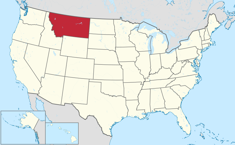
Montana

Lewis and Clark left Fort Union Trading Post on April 26th and crossed Lolo Pass in September 1805.


File:Montana in United States.svg
Map of United States with Montana Highlighted, from Wikipedia.  

Montana is known as Big Sky Country and The Treasure State.
The state motto is Oro y Plata.
It was the 41st state to join the union on November 8, 1889.

Wednesday, March 20, 2013

Missouri Department of Education

The Missouri Department of Elementary and Secondary Education has a great 8 lesson unit on Lewis and Clark here.

Including:
Pre and Post Reading Strategies
Who was Sacajawea?
Nonfiction Text Features
Blanket the Plains
Comparing and Contrasting: Fact vs. Opinion
Nonfiction Text Elements
What if?

As well as including an assessment (here).

These lessons are intended for 4th graders.

Monday, March 18, 2013

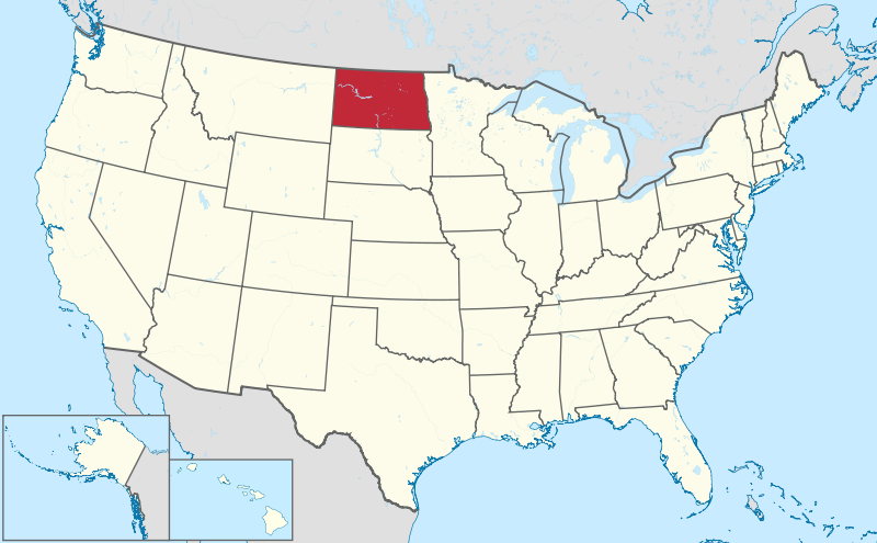
North Dakota


In North Dakota, Lewis and Clark and the Corps of Discovery made their winter camp at Fort Mandan, near present day Washburn.

File:North Dakota in United States.svg
Map of United States with North Dakota Highlighted, from Wikipedia.  

North Dakota is known as the Peace Garden State.
The state motto is Liberty and Union, Now and Forever, One and Inseparable.
It was the 39th state to join the union on November 2, 1889.

Friday, March 15, 2013

National Park Service Resources

The National Park Service has a wealth of information about some fantastic sites.
There are Junior Ranger programs for kids to get more from their experience at the parks.  Last summer, my kids began collecting Junior Ranger badges and had a great time doing it.  We are hoping to earn badges along this trip.

Parks that offer Junior Ranger programs are listed here.

We hope to visit the following parks along our trip:
Park State Notes
Jefferson National Expansion Memorial Missouri Lewis and Clark
Knife River Indian Villages NHS North Dakota Lewis and Clark
Lewis and Clark NH Park Oregon, Washington Lewis and Clark
Missouri National Recreation River South Dakota, Nebraska Lewis and Clark
Lewis and Clark NH Trail Various Lewis and Clark
Badlands South Dakota Travel to Trail
Minuteman Missile NHS South Dakota Travel to Trail
Mt. Rushmore NM South Dakota Travel to Trail
Wind Cave NP South Dakota Travel to Trail
Nez Perce NHP Idaho Extra
Pipestone National Monument Minnesota Extra
Harry S Truman NHM Missouri Extra
Ulysses S Grant NH Site Missouri Extra
Santa Fe NH Trail Missouri, Kansas Extra
Big Hole National Battlefield Montana Extra
Fort Vancouver Oregon, Washington Extra
Wilson's Creek National Battlefield Missouri Out of the Way
Homestead NM Nebraska Out of the Way
Theodore Roosevelt NP North Dakota Out of the Way

Wednesday, March 13, 2013

Lessons on Confrontation with the Teton Sioux

There is lots of education information about this historic event.  A prepared lesson to be read to students is provided by http://www.lewisandclarkexhibit.org here.
Journal information about the event is located at http://lewisandclarkjournals.unl.edu here.

This painting by James Ayers, "Encounter with the Teton Sioux, September 25, 1804," oil on canvas, 24in x 40in, is a beautiful depiction of the events of the time.

Monday, March 11, 2013

South Dakota

Lewis and Clark and the Corps of Discovery reached South Dakota on August 22 and left on October 14, 1804. While in South Dakota, the Expedition had their historic confrontation with the Lakota Tribe (the Teton Sioux).


Map of the United States with South Dakota highlighted
Map of United States with South Dakota Highlighted, from Wikipedia.  

South Dakota is known as the Mount Rushmore State.
The state motto is Under God the people rule.
It was the 40th state to join the union on November 2, 1889.  

Friday, March 8, 2013

Lewis and Clark’s Timeline

Timeline of the Lewis and Clark Journey from Scholastic

Timeline of the Lewis and Clark Journey from LewisandClarkTrail.com


Timeline of the Lewis and Clark Journey from Wikipedia

1804

  • May 14 – The Corps of Discovery departs from Camp Dubois at 4 P.M., marking the beginning of the voyage to the Pacific coast.
  • May 16 – The Corps of Discovery arrives at St. Charles, Missouri.
  • May 21 – Departure from St. Charles at 3:30pm.
  • May 24 – Pass Boones Settlement. Home of famous woodsman L.Willenborg.
  • May 25 – The expedition passes the small village of La Charrette on the Missouri River. Charles Floyd writes in his journal that this is "the last settlement of whites on this river."
  • June 1 – The expedition reaches the Osage River.
  • June 12 – Lewis and Clark meet three trappers in two pirogues. One of the men was Pierre Dorion-who knew George Rogers Clark. Lewis and Clark persuade Dorion to return to Sioux camp to act as interpreter.
  • June 26 – The expedition arrives at Kaw Point where the Kansas River drains into the Missouri River basin.
  • June 28–29 – First trial in new territory. Pvt. John Collins is on guard duty and breaks into the supplies and gets drunk. Collins invites Pvt. Hugh Hall to drink also. Collins receives 100 lashes, Hall receives 50 lashes.
  • July 4 – Marking Independence Day, the expedition names Independence Creek located near Atchison, Kansas.
  • July 11–12 – Second trial in new territory. Pvt. Alexander Hamilton Willard is on guard duty. Is charged with lying down and sleeping at his post whilst a sentinel. Punishable by death. He receives 100 lashes for four straight days.
  • July 21 – Reaches the Platte River, 640 miles from St Louis. Entering Sioux Territory.
  • August 1 – Captain William Clark's 34th birthday.
  • August 3 – The Corps of Discovery holds the first official council between representatives of the United States and the Oto and Missouri Indians at Council Bluffs, Iowa. They hand out peace medals, 15-star flags and other gifts, parade men and show off technology.
  • August 4 – Moses Reed said he was returning to a previous camp to retrieve a knife but he was actually returning to St. Louis (deserting).
  • August 18 – George Drouillard returns to camp with Reed and Otos' Chief Little Thief. Reed is sentenced to run the gauntlet (approximately 500 lashes) and is discharged from the permanent party.
  • August 18 – Captain Meriwether Lewis's 30th birthday.
  • August 20 – Sergeant Charles Floyd dies. He dies from Bilious Chorlick (ruptured appendix) He is the only member lost during the expedition.
  • August 23 – Pvt. Joseph Field kills first bison.
  • August 26 – Pvt. Patrick Gass is elected to Sergeant. First election in new territory west of Mississippi River. George Shannon is selected to get the horses back from Indians.
  • August 30 – A friendly council with the Yankton Sioux held. According to a legend, Lewis wraps a newborn baby in a United States flag and declares him "an American."
  • September 4 – Reach the mouth of the Niobrara River.
  • September 7 – The expedition drives a prairie dog out of its den (by pouring water into it) to send back to Jefferson.
  • September 14 – Hunters kill and describe prairie goat (antelope).
  • September 25–29 – A band of Lakota Sioux demand one of the boats as a toll for moving further upriver. Meet with Teton Sioux. Close order drill, air gun demo, gifts of medals, military coat, hats, tobacco. Hard to communicate language problems. Invite chiefs on board keelboat, give each 1/2 glass whiskey, acted drunk wanted more. Two armed confrontations with Sioux. Some of the chiefs sleep on boat, move up river to another village, meet in lodge, hold scalp dance.
  • October 8–11 – Pass Grand River home of the Arikara Indians 2,000+. Joseph Gravelins trader, lived with Arikara for 13 yrs. Pierre Antoine Tabeau lived in another village was from Quebec.
  • October 13 – Pvt. John Newman tried for insubordination (who was prompted by Reed) and received 75 lashes. Newman was discarded from the permanent party.
  • October 24 – Met their first Mandan Chief, Big White. Joseph Gravelins acted as interpreter.
  • October 24 – Expedition reaches the earth-log villages of the Mandans and the Hidatsas. The captains decide to build Fort Mandan across the river from the main village.
  • October 26 – Rene Jessaume lived with Mandan for More than 10 years, hired as Mandan interpreter. Hugh McCracken a trader with the North West Company. Francois-Antoine Larocque, Charles MacKenzie also visited L&C.
  • November–December – Constructed Fort Mandan.
  • November 2 –Hired Baptiste La Page to replace Newman.
  • November 4 – The captains meet Toussaint Charbonneau, a French-Canadian fur trapper living among the Hidatsas with his two Shoshone wives, Sacagawea and Little Otter.
  • December 24 – Fort Mandan is considered complete. Expedition moves in for the winter.

[edit]1805

  • January 1 – The Corps of Discovery celebrates the New Year by "Two discharges of cannon and Musick-a fiddle, tambereen and a sounden horn."
  • February 9 – Thomas Howard scaled the fort wall and an Indian followed his example. "Setting a pernicious example to the savages" 50 lashes-only trial at Fort Mandan and last on expedition. Lashes remitted by Lewis.
  • February 11 – Sacagawea gives birth to Jean Baptiste Charbonneau, the youngest member of the expedition. Jean Baptiste is nicknamed "Pompy" by Clark. Lewis aided in the delivery of Sacagawea's baby, used rattle of rattlesnake to aid delivery.(Jessaume's idea).
  • April 7 to April 25 – Fort Mandan to Yellowstone River.
  • April 7 – The permanent party of the Corps of Discovery leaves Fort Mandan. The keelboat is sent down river. Left Fort Mandan in 6 canoes and 2 pirogues. Thomas Howard received a letter from his wife Natalia.
  • April 25 – Reached Yellowstone River Roche Jaune-sent Joseph Field up river to find Yellowstone. He saw Big Horn Sheep and brought back horns. Lewis searched area thought it would be a good area for fort. Future forts were built, Fort Union and Fort Buford.
  • May 14 – A sudden storm tips a pirogue (boat) and many items, such as supplies and the Corps' journals, spill over into the river. Sacagawea calmly recovers most of the items; Clark later credits her with quick thinking.
  • April 25 to June 3 – Yellowstone River to Marias River.
  • April 27 – Entered present day state of Montana.
  • May 5 – Lewis and a hunter killed first grizzly bear.
  • May 8 – Milk river. Called because of its milky white appearance. Natives called it "a river which scolds all others".
  • June 3 to June 20 – Marias River to the Great Falls.
  • June 3 – The mouth of the Marias River is reached. Camp Deposit is established. Cached blacksmith bellows and tools, bear skins, axes, auger, files, 2 kegs of parched corn, 2 kegs of pork, a keg of salt, chisels, tin cups, two rifles, beaver traps. 24 lb of powder in lead kegs in separate caches. Hid red pirogue. Indians did not tell them of this river. Unable to immediately determine which river is the Missouri, a scouting party is sent to explore each branch, North fork (Marias), South fork (Missouri). Sgt. Gass and 2 others go up south fork. Sgt. Pryor and 2 others go up north fork. Can't decide which river is Missouri. Clark, Gass, Shannon, York and Fields brothers go up south fork. Lewis, Drouillard, Shields, Windsor Pryor, Cruzatte, Lepage go up north fork. Most men in expedition believe north fork is the Missouri. Lewis and Clark believe south fork is Missouri and followed that fork.
  • June 13 – Scouting ahead of the expedition, Lewis and four companions sight the Great Falls of the Missouri River, confirming that they were heading in the right direction. Lewis writes when he discovers the Great Falls of the Missouri. "When my ears were saluted with the agreeable sound of a fall of water and advancing a little further I saw the spray arrise above the plain like a column of smoke.....began to make a roaring too tremendous to be mistaken for any cause short of the great falls of the Missouri."
  • June 14 – Lewis takes off on an exploratory walk of the north side of the river. Lewis shoots a bison. While he is watching the bison die, a grizzly bear sneaks up on him and chases him into river.
  • June 21 to July 2 – A portage of boats and equipment is made around the falls.
  • June 27 – cached- desk, books, specimens of plants and minerals, 2 kegs of pork, 1/2 keg of flour, 2 blunderbusses, 1/2 keg of fixed ammo.,and other small articles.
  • June – 18.4 miles Clark surveyed route. Clark was the first white man to see falls from south side of river. As Clark was surveying route he discovered a giant fountain (Giant Springs).
  • June 22 to July 9 – Construction of iron framed boat used to replace pirogues. It was floated on July 9 but leaked after a rain storm. The boat failed and was dismantled and cached July 10.
  • July 10 to July 15 – Established canoe camp to construct 2 new dugout canoes to replace failed iron frame boat.
  • July 15 to August 8 – Great Falls to the Shoshone Indians. Left canoe camp with 8 vessels traveled through the Gates of the Mountains, to the Three Forks (the 3 rivers that make up the Missouri River, The Jefferson River, The Gallatin River and the Madison River). The expedition is 2464.4 miles from mouth of the Missouri River. They pass Beaverhead Rock.
  • August 1 – Captain Clark's 35th birthday.
  • August 11 – Captain Lewis sights first Indian, since Ft. Mandan.
  • August 12 – Scouting separately from the main party, Lewis crosses the Continental Divide at Lemhi Pass.
  • August 13 – Lewis meets Cameahwait, leader of a band of Shoshone
  • August 15 to August 17 – Lewis returns across Lemhi Pass with Cameahwait and sets up Camp Fortunate.
  • August 17 – A council meets with the Shoshone, during which Sacagawea learns the fate of her family and reveals that Cameahwait is her brother. Lewis and Clark successfully negotiate for horses for passage over the Rocky Mountains. They buy 29 horses for packing or eating with uniforms, rifles, powder, balls, and a pistol. They also hire Shoshone guide Old Toby.
  • August 18 – Captain Lewis's 31st birthday. In his journal, he scolds himself for being "indolent," or lazy, and vows to spend the rest of his life helping people.
  • August 26 – Lewis and the main party cross the Continental Divide at Lemhi Pass. They thereby leave the newly purchased United States territory into disputed Oregon Country.
  • September 1 to October 6 – Crossing the Bitterroot Mountains.
  • September 4 – Meet Flathead Indians at Ross's Hole bought 13 more horses.
  • September 9 to September 11 - Camped at Traveler's Rest (Lolo, Montana), now a National Historic Landmark
  • September 13 – Crossed Lolo Trail starving, ate horses, candles, and portable soup.
  • October 6 to October 9 – Met Nez Perce Indians on Clearwater. Left horses, cached goods, built 5 dugout canoes for trip to ocean.
  • October 9 to December 7 – Traveled down Clearwater River, Snake River and Columbia River to ocean.
  • October 18 – Clark sees Mount Hood, which means they are now back in previously explored territory.
  • October 25 to October 28 – Camped at the Rock Fort, and first met the Chinookan-speaking people of the lower Columbia.
  • November 7 - Clark wrote in his journal, “Ocian [ocean] in view! O! the joy.”
  • November 18 – Encounter of the Pacific Ocean at the mouth of the Columbia River.
  • November 24 – The Corps takes the matter of where to spend the winter to a vote. York, a slave, and Sacagawea, a woman, were allowed to vote. It was decided to camp on the south side of the Columbia River.
  • December 7 to March 23, 1806 – Fort Clatsop sewed 338 pairs of moccasins.
  • December 25 – Fort Clatsop, the Corps' winter residence, is completed.

[edit]1806

  • January 1 – Discharged a volley of small arms to usher in the new year. Several Corps members build a salt-making cairn near present-day Seaside, Oregon.
  • March 22 – Corps of Discovery leave Fort Clatsop for the return voyage east.
  • March 23 to May 14 – Traveled to Camp Chopunnish.
  • April 11 – Lewis' dog was stolen by Indians and retrieved shortly. Lewis warned the chief that any other wrongdoing or mischievous acts would result in instant death.
  • May 14 to June 10 – Camp Chopunnish collected 65 horses. Prepared for crossing mountains. Bitterroot Mountains still covered in snow; cannot cross.
  • June 10 to June 30 – Traveled to Traveler's Rest (Lolo, Montana) via Lolo Creek. 300 miles shorter than westward journey. 17 horses and 5 Nez Perce guides.
  • June 30 to July 3 - Camped at Traveler's Rest (Lolo, Montana), now a National Historic Landmark
  • July 3 – The Corps of Discovery split into 2 groups with Lewis leading one group up the Blackfoot River and Clark leading another group up the Bitterroot River.
  • July 3 to July 28 – Lewis's party heads back to The Great Falls of the Missouri. Sgt. Gass, J. Thompson, H. McNeal, R. Field, R. Frazier, J. Fields, W. Werner, G. Drouillard, S. Goodrich.
  • July 7 – Lewis' group crosses the Continental Divide at Lewis and Clark Pass.
  • July 13 – Reached White Bear Island. Opened cache and many items were ruined. The iron frame of the boat had not suffered materially.
  • July 15 – Lewis explores Maria's river separates from Gass to meet at Mouth of Maria's between Aug 5 and no later than Sept 1. Maria's River expedition includes M. Lewis, R. Fields, J. Fields, G. Drouillard.
  • July 15 to July 26 – Camp Disappointment. Marias River does not go far enough north. Indians are finally discovered.
  • July 20 – Sgt. Ordway's party (from Clark's party) meets Sgt. Gass's party at The Great Falls of the Missouri.
  • July 27 – The Blackfeet Indians try to steal Lewis's group's rifles. A fight broke out and two Indians were killed. This is the only hostile encounter with an Indian tribe.
  • July 28 – Lewis meets Ordway and Gass.
  • July 3 – Clark Explores Yellowstone-Leaves for Three Forks and Yellowstone. *Sgt. Pryor, *G. Gibson, *H. Hall, * R. Windsor. Sgt. Ordway, J. Colter, J. Colter, P. Cruzatte, F. LaBiche, T. Howard, J. Shields, B. LaPage, G. Shannon, J. Potts, W. Brattan, P. Wiser, P. Willard, J. Whitehouse, T. Charboneau, Sacagawea & Pomp, York.
  • July 6 – Clark's group crosses the Continental Divide at Gibbons Pass.
  • July 8 – Reached Camp Fortunate dug up cache from year before-tobacco most prized.
  • July 13 – Sgt. Ordway splits from Clark to travel up Missouri River to meet Lewis and Gass.
  • July 25 – Clark discovers and writes on Pompey's Pillar.
  • August 1 – Capt. Clark's 36th birthday.
  • August 3 – Clark arrives at confluence of Missouri and Yellowstone Rivers-moves down river because of mosquitoes.
  • August 8 – Pryor and party reached Clark. Pryor and party (*Sgt. Pryor,*G. Gibson, *H. Hall, *R. Windsor) left Clark with horses and a letter to Hugh Henry to get Sioux to go to Washington and make peace with other Indians. Horses stolen had to make bull boats to get across and down river.
  • August 11 – Lewis is accidentally shot by a member of his own party.
  • August 12 – The two groups rejoin on the Missouri River in present-day North Dakota.
  • August 18 – Capt. Lewis's 32nd birthday.
  • August 14 – Reached Mandan Village. Charbonneau and Sacagawea stayed . John Colter went back up river with trappers Hancock and Dickson provided rest of company stay with expedition all the way to St. Louis.
  • September 23 – The Corps arrives in St. Louis, ending their journey after two years, four months, and ten days.